Wednesday, November 16, 2016

Bertha Emily Binder Yates: Rest in Peace

Bertha's Story

Bertha Emily Binder Yates or Mammaw Bertie as her grandchildren knew her, 97, of Ashland, passed away peacefully Monday, Nov. 14, 2016, at her home.
She was born Dec. 20, 1918, in London, the daughter of the late John and Sarah Adams Binder.
In addition to her parents, she was preceded in death by her husband, Ira Edward Yates; her daughter, Juanita Davidson; four brothers, John Binder, Paul Binder, Robert Binder and Walter Binder; and one sister, Ollie Feltner.
Bertha was a member of Moore Street Tabernacle in Ashland. She loved going to church.  

Yates Grocery
Bertha owned and operated Yates Grocery for more than 30 years. She was an extremely hard worker and enjoyed working in her garden.
Bertha is survived by three sons, Cecil Yates and wife Pat of Lawrenceburg, Curtis Yates and wife Denise of Ashland and David Yates and wife Judith of Ashland; 13 grandchildren; 14 great-grandchildren; five great-great-grandchildren; and a sister-in-law, Hazel Binder.
A funeral service celebrating her life will be at 12:30 p.m. Friday, Nov. 18, 2016, at Kilgore & Collier Funeral Home in Catlettsburg with Pastor Danny Pancake officiating. Burial will be in Golden Oaks Memorial Gardens in Ashland.

Friday, October 28, 2016

HYDROLOGY OF PRAIRIE POTHOLES IN NORTH DAKOTA

Ground-Water Hydrology
of Prairie Potholes

in 
North Dakota

By CHARLES E. SLOAN
HYDROLOGY OF PRAIRIE POTHOLES IN NORTH DAKOTA


GEOLOGICAL SURVEY PROFESSIONAL PAPER 585-C


Prairie potholes and fens
        Prairie potholes (sloughs) are water-holding depressions of glacial origin in the prairies of the Northern United States and southern Canada. Water is supplied to the potholes by precipitation on the water surface, basin runoff, and seepage inflow of ground water. Depletion of pothole water results from evapotranspiration, overflow, and seepage outflow. Since potholes generally do not overflow, seepage outflow is the principal way in which dissolved salts can be removed. Salinity of pothole water is therefore a good indication of the seepage balance. Net seepage outflow results in fresh to brackish waters that constitute ephemeral to semipermanent ponds, whereas net seepage inflow results in brackish to saline waters that constitute semipermanent to permanent ponds.

        Prairie potholes, or sloughs, are water-holding depressions of glacial origin that occur in 300,000 square miles of prairies in north central United States and south-central Canada (fig. 1). These potholes provide the most productive wetland habitat for waterfowl in North America. Although comprising only 10 percent of the continental waterfowl-breeding, the pothole region produces about 50 percent of the duck crop in an average year and much more in bumper years (Smith and others, 1964, p. 39). Potholes also furnish water for other wildlife and livestock.


Coteau du Missouri
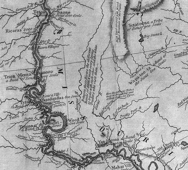
The most conspicuous glacial feature of North Dakota is the Coteau du Missouri, defined by the U.S. Geographic Board (1933) as a "narrow plateau beginning in the northwest corner of North Dakota between the Missouri River and River des Lacs and Souris River and running southeast and south, with its southern limit not well defined; and its western escarpment forming the bluffs of the Missouri." Winters (1967) discusses boundaries of the Coteau and other definitions that are in use. For this study the Coteau du Missouri is defined as that region of dead-ice moraine which lacks a well-integrated drainage system and lies between the Missouri escarpment on the northeast and the well-drained ground moraine adjacent to the Missouri River on the southwest. Figure 4 is a generalized map showing selected physical subdivisions of North Dakota including the Coteau du Missouri.
        Glacial drift west of the Coteau du Missouri consists mainly of thin ground moraine that is discontinuous and patchy near the Missouri River. West of the Missouri River, the drift is very discontinuous and, in many places, consists only of scattered erratics.


Coteau du Missouri

 The Coteau du Missouri, or Missouri Plateau, is a large plateau that stretches along the eastern side of the valley of the Missouri River in central North Dakota and north-central South Dakota in the United States. This physiographic region of Saskatchewan and Alberta is classified as the uplands Missouri Coteau which is a part of the Great Plains Province or Alberta Plateau Region which extends across the south east corner of the province of Saskatchewan as well as the south west corner of the province of Alberta.[1]Historically, in Canada the area was known as the Palliser's Triangle regarded as an extension of the Great American Desert and unsuitable for agriculture and thus designated by Canadian geographer and explorer John Palliser. The terrain of the Missouri Coteau features low hummocky, undulating, rolling hills, potholes, and grasslands.[2]


The plateau is poorly drained and is interspersed with glacial kettle lakes. It is transversed by several broad sags marking the ancient stream valleys of the eastern continuations of the Grand, Moreau, Cheyenne, Cheyenne River, Bad, and Whiterivers.
To the east of the plateau, the lowland valley of the James Riverwas formed by the lobe of the most recent ice age, separating the plateau from the Coteau des Prairies to the east.
Agriculturally the plateau is a grain and livestock region.


        Cottonwood Lake Study Area North Dakota Wetlands 


The Cottonwood Lake Study Area is located in Stutsman County, North Dakota, about 35 miles northwest of the Northern Prairie Wildlife Research Center (NPWRC) headquarters near Jamestown. 

Today the Cottonwood Lake Study Area is internationally recognized as one of the most intensively studied wetland complexes in North America. More than 80 scientific publications, graduate theses, and presentations at scientific conferences resulting from these studies provide the bulk of information currently available to guide wetland management in the prairie pothole region of the U.S. and Canada. According to Euliss, one of the greatest contributions of theCottonwood Lake effort is that it "provides invaluable baseline data on the hydrological, chemical, and biological attributes upon which to base comparisons with ongoing research, including studies on wetland restoration and wetland monitoring." In addition, the understanding of the interrelation of hydrological, chemical, and biological processes revealed by research at the site provides the scientific foundation that allows wetland managers to understand the outcome of different management options. 


Cottonwood Lake area
Pothole C1 (fig. 11) is in the Cottonwood Lake area of the SW¼, sec. 32, T. 142 N., R. 66 W., about 12 miles west of Buchanan, N. Dak. Pothole C1 is surrounded by surficial glacial till in high-relief stagnation moraine. The pothole is in a deep basin that shows evidence of a high-water mark about 6 feet above the highest water level that occurred during the study. A well-developed wave-cut platform that is very stony surrounds the pothole. The pothole is brackish and semipermanent according to the classification of Stewart and Kantrud (1969).


The Coteau des Prairies is a plateau approximately 200 miles in length and 100 miles in width (320 by 160 km), rising from the prairie flatlands in eastern South Dakota, southwestern Minnesota, and northwestern Iowa in the United States.
Prairie Coteau of North Dakota.

 The southeast portion of the Coteau comprises one of the distinct regions of Minnesota, known as Buffalo Ridge.


The flatiron-shaped plateau was named by early French explorers from New France(Quebec), Coteaumeaning "slope"[citation needed] in French.
The plateau is composed of thick glacial deposits, the remnants of many repeated glaciations, reaching a composite thickness of approximately 900 feet (275 m). They are underlain by a small ridge of resistant Cretaceous shale. During the last (Pleistocene) Ice Age, two lobes of the glacier appear to have parted around the pre-existing plateau and further deepened the lowlands flanking the plateau.


The plateau has numerous small glacial lakes and is drained by the Big Sioux River in South Dakota and the Cottonwood River in Minnesota. Pipestonedeposits on the plateau have been quarried for hundreds of years by Native Americans, who use the prized, brownish-red mineral to make their sacred peace pipes. The quarries are located at Pipestone National Monument in the southwest corner of Minnesota and in adjacent Minnehaha County, South Dakota.
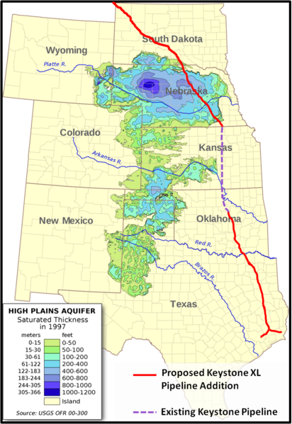
Depth and location of Ogallala Aquifer

 As may be seen from the map on your left, the ecologically sensitive areas under discussion that begin adjacent to the tar sands deposits in Alberta, Canada, continue into the High Prairie potholes of North Dakota, through the James River watershed, Cottonwood Lake and the COTEAU DU MISSOURI, andcrosses portions of the Ogallala Aquifer .

The underlying glacial pothole formations do not lend themselves to easy drainage, are susceptible to fluid transfers between layers, are permeable to exterior elements contamination, and exchange surface liquids with the underlying aquifer with ease. 

 The Ogallala aquifer has emerged as an important point in the debate. In June, two scientists from Nebraska called for a special study to determine how an oil spill would affect it, and Republican Sen. Mike Johanns of Nebraska has asked the State Department to consider an alternate, more easterly route that would avoid it. Twenty scientists from top research institutions recently signed a letter urging President Obama not to approve the pipeline because of environmental concerns.

 Because it's the most heavily used aquifer in the United States and supplies about 30 percent of the groundwater pumped for irrigation nationwide. The Ogallala aquifer (also known as the High Plains aquifer) covers 175,000 square miles, an area larger than the state of California, and spans eight states — Nebraska, South Dakota, Wyoming, Colorado, Kansas, Oklahoma, Texas and New Mexico. 

  A valve broke at a pumping station in southern North Dakota along the first leg of its Keystone pipeline system. The breach released about 500 barrels of Canadian heavy crude inside the facility and set off a geyser of oil that reached above the treetops in a nearby field. It was only ten months ago that the pipeline began transporting bitumen from Alberta's oil sands mines to refineries in Patoka, Illinois. ( Stacy Feldman, InsideClimate News and Elizabeth McGowan)

Needless to say, there can be no mistakes here, not with the lives,drinking water and food supply of  millions Americans at risk. The ecosystems mentioned here are only the largest and most well  known. From the arboreal forests of Alberta Canada, glacial tills of the High Plateau, the wetlands of the Dakotas and the Missouri River Watershed, the treasures of Utah, Nebraska all the way through Texas, this is a gift  to be treasured and protected at all cost. 


The certain ecological damage to wildlife and the natural resources of our Great Plains breadbasket is too precious to risk for a few drops of oil that will enrich only a few and do nothing to add to our American jobs or energy independence. Even if that were not true, we still could not afford this debacle. The destruction in Alberta, in our American west, the multiple dangers of pursuing these out dated and destructive projects is the epitome of arrogance. For only a fraction of the fortune that is being reaped from our lands, and investment of true American spirit, renewable energy could be ours in our lifetimes.  As the space program was created and successfully implemented in the 1960's through sheer political will and popular support, so can we today continue creating the necessary energy technologies to eliminate the need for these destructive and fatal practices. It is the height of foolishness to even consider moving forward into the future with the old end game of dirty oil, toxic lands, polluted water and unbreathable air.  Worse yet, to see all that is precious to us be destroyed by the avarice of greed and the Worship of Mammon would be a failing of monumental and irreversible proportions.


Wednesday, October 26, 2016

Standing Rock Stands on Free Speech

BREAKING: Feds Shoot Down Furious North Dakota Cops and DAPL Corp, Telling Them There Are No Grounds To Evict Growing Pipeline Protest Camp


The growing encampment that is a living, breathing protest against the four-state Dakota Access pipeline has most everything it needs to be self-sustaining: food, firewood, fresh water and shelter. Everything except, according to Republican Rep Kevin Cramer, permission to be on the federal land in North Dakota.
According to James MacPherson of Time, Federal officials say they will not evict the Oceti Sakowin, or Seven Council Fires camp, due to free speech reasons, even though it’s on U.S. Army Corps of Engineers land near the confluence of the Missouri and Cannonball rivers that many Native Americans believe is still rightfully owned by the Standing Rock Sioux under a nearly 150-year-old treaty.
“We’re not leaving until we defeat this big black snake,” camp spokesman Cody Hall said of the pipeline.
Republican U.S. Rep. Kevin Cramer, North Dakota’s only House member, has sided with the pipeline company against the protectors and believes the camp is illegal.
“If that camp was full of people advocating for fossil fuels, they would have been removed by now,” Cramer said. “There is some discretionary enforcement going on.”
Primary encampment
 Oceti Sakowin Camp.Cannon Ball, ND
The camp is the overflow from smaller private and permitted protest sites nearby and REALLY began growing in August. The gathering has been called the largest gathering of Native American nations in history, all there to protect the land and water from Dallas-based Energy Transfer Partners’ $3.8 billion Dakota Access pipeline, which officials say threatens sacred sites, burial grounds, and a river that’s a source of water for millions. The company has already destroyed some sacred areas while using hired security forces with pepper spray and attack dogs to try to hold back the protectors.
MacPherson also notes that Corps spokeswoman Eileen Williamson said the agency is encouraging people to relocate to areas where there is a permit, such as a nearby smaller camp where demonstrators have been allowed to legally protest on federal lands managed by the agency.
Williamson mentions the pesky “free speech” that Americans are allowed:“We don’t have the physical ability to go out and evict people — it gives the appearance of not protecting free speech,” she said. “Our hands are really tied.”
Cramer speculates, without evidence, that the “bigger problem” of the camp is “the illegal activity that may be orchestrated from there.”  About 95 people have been arrested in the pipeline protests, some as far as 70 miles away from the camp, since early August, but none at the camp itself. Protectors deny state officials’ false charge, and Hall says the camp promotes peaceful protest.
“People don’t leave from the camp with malicious intent to do harm,” Hall said. “There are always going to be a few bad eggs in any group you can’t the message to.”
Complicating the issue is a grazing lease on that land. The renter, David Meyer, is responsible for the condition of the land. He could enforce his lease and have people removed, Williamson said, but hasn’t requested any intervention. Meyer recently sold part of his historic Cannonball Ranch to Energy Transfer Partners for an undisclosed price; he hasn’t returned telephone calls from The Associated Press seeking comment.
 
The Standing Rock Sioux has challenged the Army Corps of Engineers’ decision to grant permits for the pipeline that is intended to carry North Dakota oil to Illinois. Due to a federal court decision, construction has stopped within 20 miles on either side of Lake Oahe, a Missouri River reservoir that is near the encampment. The Departments of Justice, Army and Interior also has said it will “reconsider any of its previous decisions” on land that borders or is under the lake.
Hall, a member of South Dakota’s Cheyenne River Sioux Tribe, said the Sioux “never ceded” the land on which they’re camping. He said they are preparing to stay through the winter by stockpiling firewood, heating stoves and warmer clothes. But there’ll be no permanent structures built, Hall said.
“We will leave this camp as we found it,” he said.
So who’s land is it? According to the treaty, it is the land of the Natives, but according to some, it is the land of the Army Corps of Engineers. Are the treaties still respected or are they forgotten in favor of money? Either way, the Corps said they will respect “free speech” for now and allow the camp to continue! 

Thursday, October 20, 2016

 The Family Group of William Brown.
~
by Justin Sanders.


The earliest known ancestors of our Brown line were William and Ann Brown of Bristol Parish, Henrico County, Virginia. Although records pertaining to this couple are few in number and span only a sixteen-year period, those that have been located suffice to offer a basic understanding of their family group.
The earliest record found thus far shows William and Ann were residing in Henrico County by 1721, the year in which their youngest known son, John, was born. A single-line entry in the birth registry of the Bristol Parish Vestry Book, states: “John, s/o William & Anne Brown, b. Aug. 30, 1721.” 1
Henrico County was the second settlement of the Virginia Colony, established in 1611 a short distance upriver from Jamestown. In 1721 the county and Bristol Parish encompassed a vast area that was later subdivided into several jurisdictions. Unless an earlier deed is found, it is impossible to say for certain where William’s family was then located. Within a few years of that date, however, a pair of land records hone William’s whereabouts into a small pocket in present-day Chesterfield County.
1 Births from Bristol Parish of Henrico, Prince George and Dinwiddie, in Bristol Parish Vestry Book, p. 5.


http://search.ancestry.com/Browse/BookView.aspx?dbid=49093&iid=FLHG_BritishBristolParishRegiHen-0125


The White Man Came to Stay: WPA Writers Program 1941 (Sponsored by Franklin Co Va. School Board)


Friday, September 30, 2016

. Accessing the American Interior c. 1775

Accessing the Interior c. 1788

This map project on the Roads and Trails of Colonial America started  by questioning what routes the immigrant ancestors used during their southern and western migrations. The assumption was that our earliest immigrant ancestors were limited to the waterways which accessed the coast and an occasional Indian path. And for the most part, that was true, However, further research proves that the Native population used trails and routes extensively to travel and trade throughout the hinterland and even to the coast. The challenge was for our early ancestors to identify the many routes and survive the journey.
1. Accessing the American Interior
Settled before the end of the Revolutionary War by the Over-the-Mountain Men, the American interior, west of the Appalachians, was accessible by way of the Valley Road down to theWilderness Road. The northern branch of the Wilderness Road led up through the Cumberland Gap to the interior of the future State of Kentucky, and the southern branch led down the Holston to the interior of the future State of Tennessee.
By 1765 the Great Wagon Road, running from Pennsylvania to Georgia along the Blue Ridge Mountains, was improved to accept wagons. Traveling south up the Valley of Virginia. the road rose up to the headwaters of the James River at Roanoke VA. Here the road split. The western branch, known as the Valley Road, descended southwest into the New River Valley. And, the southern branch continued on to the Piedmont of North and South Carolina, descending to Ft. Augusta GA on the Savannah River.
Great Valley Road also called in various parts the "Great Wagon Road," "Great Warriors' Path," "Valley Pike," "Carolina Road," or "Trading Path," was the most important Colonial American route for settlers of the mountainous backcountry of the southern British colonies. It went from Philadelphia, Pennsylvania over to the Shenandoah Valley of Virginia, forking into the Tennessee Valley and Knoxville. The other fork went more south into the Piedmont Region of North Carolina and then to its terminus on the Savannah River at Augusta, Georgia. From Philadelphia to Augusta was 735 miles (1183 km).
    Great Valley Road, Family Search <https://familysearch.org/learn/wiki/en/Great_Valley_Road> 12 November 2014.

2. The Valley Road (1765)

The Valley Road began at Roanoke VA past the headwaters of the James River:
-Turning southwest, the road led up to the headwaters of the Roanoke and then downhill into the New River Valley.
-Continuing southwest, the Valley Road rose up to meet the headwaters of the New River which flows north to meet up with the Kanawha en route to the Ohio at Point Pleasant (W) VA. Here, Ft. Chiswell stood as a bastion against marauding Indians. By 1775 this was the end of the road.
-Were you to continue uphill, you would enter a pass (vic. Atkins VA) where the path begins its descent to the Holston.
-Continuing down the Holston, the land begins to open up and the path leads to the current Virginia/ Tennessee boarder (vic. Bristol VA). But, the settlers didn't know that; as the first settlers believed they were part of the abortive Colony of Transylvania.
-And, the path continues southwest down the Holtson to its confluence with the French Broad to form the Tennessee River near Knoxville TN.
Research note: In 1772 early settlers formed the extra-legal Watagua Republic. In 1776 the residents in the lower Holston Valley petitioned for organization as a county of Virginia which was declined. In 1777 North Carolina organized the western settlements in the lower Holston as Washington County. And from 1784 to 1788, these western lands seceded from North Carolina to form the unsuccessful State of Franklin.
The entire road, from Knoxville TN up through the Holston Valley then down through the New River Valley then down through the Shenandoah Valley and beyond has been called the Valley Road. Perhaps, the name depended on what section of the road you were on and when. My use of the term Valley Road is to differentiate the section of road which splits off the Great Wagon Road at Roanoke VA from the main road which continued down through the Carolinas to Georgia.

3. Daniel Boone and the Wilderness Road (1775)

In 1775 Daniel Boone of the Yadkin Valley of North Carolina was hired by Richard Henderson of the Transylvania Company to blaze a trail from Ft. Chiswell (now Wytheville VA) down the Holston and then up the Cumberland Gap to the interior of what is now Kentucky. The Transylvania Company illegally purchased much of central Kentucky and eastern Tennessee from the Cherokees, who didn't "own" the land, with the intent to establish a new Colony of Transylvania. And, Boone was in on the deal.
The north branch of the Wilderness Road was blazed by Daniel Boone in 1775:
-Starting at Ft. Chiswell, Boone followed the path up into the gap and then down the Holston to what is now Bristol VA.
-From Bristol, Boone continued southwest to what is now Kingsport TN.
-From Kingsport, Boone started northwest, up and over to the Clinch River Valley.
-Then down the Clinch, west to the Cumberland Gap (vic. Middlesborough KY).
- Daniel Boone continued up through the Gap into the heart of Kentucky, founding the town of Boonesborough, the designated capital of the Colony of Transylvania.

4. Populating the Interior

Success breeds success. One of the onerous British prohibitions prior to the Revolution was the prohibition of settlement west of the Appalachians. But with the onset of war, the "lid" was lifted off the boiling pot of westward migration. Even as the Revolution was raging, settlers were pouring down the Great Wagon Road then down the Valley Road to the intersection with theWilderness Road heading for Kentucky and Tennessee.
Before Boone, the road ended at Ft. Chiswell VA. Afterwards, the settlers were not just grizzled mountain men and "long hunters." Instead, our Over-the-Mountain Men brought their wives and children and household goods and livestock, looking for new lands to settle. And as traffic increased, the path was widened.
From Roanoke, settlers with all their possessions and wagons had easy access down the valley toward Tennessee and Kentucky. However at the new end of the road (vicinity Bristol VA), theWilderness Road narrowed into a horse path. Reportedly, the settlers had to dump their possessions and try to sell their wagons to proceed to the hinterland.
Either at Bristol or a little further down the Holston in the vicinity of Kingsport TN, the Wilderness Road split. The north branch, which was Boone's original trail to the Cumberland Gap, went north into Kentucky. And, the south branch of the Wilderness Road ran either next to the Holston River toward Knoxville TN where the Holston joined the French Broad to form the Tennessee River.
The Wilderness Road, opened in 1775 into central Kentucky, and branched off the Great Valley Road in southwest Virginia at Bristol (Sapling Grove). . .From the terminus of the Great Valley Road at Knoxville, Avery's Trace to Nashville opened in 1788, and the Georgia Road to Athens opened in 1805.
    Great Valley Road, Family Search <https://familysearch.org/learn/wiki/en/Great_Valley_Road> 12 November 2014.

5. Avery's Trace to Nashville c. 1788

In 1787 the North Carolina Legislature authorized creation of a road to the settlements on the Cumberland River. In 1788 Avery's Trace (or the Nashville Road) was opened:
-From Clinch Mountain above Knoxville southwest down the Tennessee to Ft. Southwest Point (now Kingston) TN and the confluence with the Clinch River
-From Ft. Southwest Point northwest to Ft. Blount (vic. Gainesboro) TN on the Cumberland River
-West down the Cumberland to Ft. Bledsoe (vic. Castalian Springs) TN
-West to Ft. Nashboro (now Nashville) TN.

6. Jackson's Military Road c. 1820

Traveling southwest from Nashville TN, Jackson's Military Road,  constructed 1816 to 1820, wound south to Columbia TN then southwest to Muscle Shoals AL where it crossed the Tennessee River. Following the old Natchez Trace, the road went again southwest to Tupelo MS where it picked up the Tombigbee River. Heading south, the road followed the Tombigbee to Columbus MS. Here the road went south, crossing the Noxubee Swamp toward Meridian MS and then Hattiesburg MS and then south again to Madisonville LA on the north shore of Lake Pontchartrain, just across from New Orleans.
Research note. Jackson's Military Road went out of use; as failure to repair the corduroy roads across the swamp made the road impassible.
Jackson's Military Road has been cited as a primary route south to lower Mississippi. But it wasn't; as the road wasn't completed until 1820 and almost immediately fell into disrepair. The earlier Gaine's Trace which intersected the Three-Chopped Way at Ft. Stephens AL and wended up the Tombigbee River to the Tennessee, was one of the routes open during the period of "Mississippi Fever."

Caveat

This site is provided for reference only. Except where specifically cited, information contained is conjecture and should not be considered as fact.
HomeIndexAbout Me

Saturday, September 24, 2016

Solomon Collins b. 1813 revised

Solomon Collins

b. 1813

Ashe Co. North Carolina

Solomon Collins was born in Ashe Co. NC. in 1813. His father’s place of birth, supported by 40 years of census claims, was born South Carolina. There is no record available as to his identity. There are claims that his father is Elisha Collins, b. 1783 in Kentucky, . This is contradictory in supporting Elisha as being the father of Solomon, regardless of the “opinion” of Roberta Estes! Those claims are not supported by fact. Solomon himself states in a census report his father was born in
South Carolina.

Solomon seems to have followed the same migration path as many did, and went from Ashe Co. NC. to Manchester, Clay Co. Ky.

Manchester was the center of Cherokee life in Ky., and was home to Chief Red Bird Aaron Brock, Dragging Canoe, Bob Benge, Double Head, and King David Benge among others. Solomon was listed from 1840 through 1880 as ”mulatto”, a designation given him by the census, when most likely, he and his kin were Native American. Being listed as “mulatto”, their rights as Native Citizens of the United States were taken away.


Solomon married (1) Mary Polly Hallen, and (2) Charity Hollingsworth, one of their sons was Andrew Jackson Collins who married

Clarinda Armstrong


their daughter, America, (1887-1963) married Boyd Cornwell.

Andrew Jackson was born in Ky. 1855 and died in Clay Co.1926. Boyd Cornwell died in Chesapeake Ohio in 1951.
1840 Federal Census

1840 United States Federal Censuolomon

Collins

Name:
Solomon Collins
County:
Clay
State:
Kentucky
Free White Persons - Males - 30 thru 39:
1
Total - All Persons (Free White, Free Colored, Slaves):
1
Persons Employed in Manufacture and Trade:
1
Free White Persons - 20 thru 49:
1
Total Free White Persons:
1
Total All Persons - Free White, Free Colored, Slaves:
1

1850 S1850 Federal Censustates Federal Census  olomo1n Collen

1850 Federal Census

Name:


Solomon Collen
[Solomon Collins] 
Age:
37
Estimated birth year:
abt 1813
Birth Place:
North Carolina
Color:
Mulatto
Gender:
Male
Home in 1850 (City,County,State):
Kentucky, Clay, Kentucky
Family Number:
560
Household Members:
Name
Age
37
23
8
3
1
20


ons1860: Federal Census


Name:
Soloman Collins

Age in 1860:
46
Birth Year:
abt 1814
Birthplace:
North Carolina
Home in 1860:
Clay, Kentucky
Race:
Mulatto
Gender:
Male
Post Office:
Manchester
Value of real estate:
Household Members:
Name
Age
46
36
18
13
11
9
7
4
2


187110 1870FFederal Censusederal

Name:
Solomon Colins

Birth Year:
abt 1814
Age in 1870:
56
Birthplace:
North Carolina
Home in 1870:
Precinct 1, Clay, Kentucky
Race:
Mulatto
Gender:
Male
Value of real estate:
Post Office:
Manchester
Household Members:
Name
Age
56
50
21
19
17
13
11


1880:Federal Census

Name:
Soloman Collins

Home in 1880:
Manchester, Clay, Kentucky
Age:
65
Estimated birth year:
abt 1815
Birthplace:
North Carolina
Relation to head-of-household:
Self (Head)
Spouse's name:
Mary Collins
Father's birthplace:
South Carolina
Mother's birthplace:
Virginia
Neighbors:
Occupation:
Farming
Marital Status:
Married
Race:
Mu
Gender:
Male
Cannot read/write:

Blind:

Deaf and dumb:

Otherwise disabled:

Idiotic or insane:
Household Members:
Name
Age
65
55
13


Here, Solomon is living next door to Perry Collins, son of Willam and Lefy Powell Collins. Perry moves to Letcher Co. and marries a Mary Collins. Her family and maiden name are unknown at this time.