Friday, October 28, 2016

HYDROLOGY OF PRAIRIE POTHOLES IN NORTH DAKOTA

Ground-Water Hydrology
of Prairie Potholes

in 
North Dakota

By CHARLES E. SLOAN
HYDROLOGY OF PRAIRIE POTHOLES IN NORTH DAKOTA


GEOLOGICAL SURVEY PROFESSIONAL PAPER 585-C


Prairie potholes and fens
        Prairie potholes (sloughs) are water-holding depressions of glacial origin in the prairies of the Northern United States and southern Canada. Water is supplied to the potholes by precipitation on the water surface, basin runoff, and seepage inflow of ground water. Depletion of pothole water results from evapotranspiration, overflow, and seepage outflow. Since potholes generally do not overflow, seepage outflow is the principal way in which dissolved salts can be removed. Salinity of pothole water is therefore a good indication of the seepage balance. Net seepage outflow results in fresh to brackish waters that constitute ephemeral to semipermanent ponds, whereas net seepage inflow results in brackish to saline waters that constitute semipermanent to permanent ponds.

        Prairie potholes, or sloughs, are water-holding depressions of glacial origin that occur in 300,000 square miles of prairies in north central United States and south-central Canada (fig. 1). These potholes provide the most productive wetland habitat for waterfowl in North America. Although comprising only 10 percent of the continental waterfowl-breeding, the pothole region produces about 50 percent of the duck crop in an average year and much more in bumper years (Smith and others, 1964, p. 39). Potholes also furnish water for other wildlife and livestock.


Coteau du Missouri
The most conspicuous glacial feature of North Dakota is the Coteau du Missouri, defined by the U.S. Geographic Board (1933) as a "narrow plateau beginning in the northwest corner of North Dakota between the Missouri River and River des Lacs and Souris River and running southeast and south, with its southern limit not well defined; and its western escarpment forming the bluffs of the Missouri." Winters (1967) discusses boundaries of the Coteau and other definitions that are in use. For this study the Coteau du Missouri is defined as that region of dead-ice moraine which lacks a well-integrated drainage system and lies between the Missouri escarpment on the northeast and the well-drained ground moraine adjacent to the Missouri River on the southwest. Figure 4 is a generalized map showing selected physical subdivisions of North Dakota including the Coteau du Missouri.
        Glacial drift west of the Coteau du Missouri consists mainly of thin ground moraine that is discontinuous and patchy near the Missouri River. West of the Missouri River, the drift is very discontinuous and, in many places, consists only of scattered erratics.


Coteau du Missouri

 The Coteau du Missouri, or Missouri Plateau, is a large plateau that stretches along the eastern side of the valley of the Missouri River in central North Dakota and north-central South Dakota in the United States. This physiographic region of Saskatchewan and Alberta is classified as the uplands Missouri Coteau which is a part of the Great Plains Province or Alberta Plateau Region which extends across the south east corner of the province of Saskatchewan as well as the south west corner of the province of Alberta.[1]Historically, in Canada the area was known as the Palliser's Triangle regarded as an extension of the Great American Desert and unsuitable for agriculture and thus designated by Canadian geographer and explorer John Palliser. The terrain of the Missouri Coteau features low hummocky, undulating, rolling hills, potholes, and grasslands.[2]


The plateau is poorly drained and is interspersed with glacial kettle lakes. It is transversed by several broad sags marking the ancient stream valleys of the eastern continuations of the GrandMoreauCheyenneCheyenne RiverBad, and Whiterivers.
To the east of the plateau, the lowland valley of the James Riverwas formed by the lobe of the most recent ice age, separating the plateau from the Coteau des Prairies to the east.
Agriculturally the plateau is a grain and livestock region.


        Cottonwood Lake Study Area North Dakota Wetlands 


The Cottonwood Lake Study Area is located in Stutsman CountyNorth Dakota, about 35 miles northwest of the Northern Prairie Wildlife Research Center (NPWRC) headquarters near Jamestown

Today the Cottonwood Lake Study Area is internationally recognized as one of the most intensively studied wetland complexes in North America. More than 80 scientific publications, graduate theses, and presentations at scientific conferences resulting from these studies provide the bulk of information currently available to guide wetland management in the prairie pothole region of the U.S. and Canada. According to Euliss, one of the greatest contributions of theCottonwood Lake effort is that it "provides invaluable baseline data on the hydrological, chemical, and biological attributes upon which to base comparisons with ongoing research, including studies on wetland restoration and wetland monitoring." In addition, the understanding of the interrelation of hydrological, chemical, and biological processes revealed by research at the site provides the scientific foundation that allows wetland managers to understand the outcome of different management options. 


Cottonwood Lake area
Pothole C1 (fig. 11) is in the Cottonwood Lake area of the SW¼, sec. 32, T. 142 N., R. 66 W., about 12 miles west of Buchanan, N. Dak. Pothole C1 is surrounded by surficial glacial till in high-relief stagnation moraine. The pothole is in a deep basin that shows evidence of a high-water mark about 6 feet above the highest water level that occurred during the study. A well-developed wave-cut platform that is very stony surrounds the pothole. The pothole is brackish and semipermanent according to the classification of Stewart and Kantrud (1969).


The Coteau des Prairies is a plateau approximately 200 miles in length and 100 miles in width (320 by 160 km), rising from the prairie flatlands in eastern South Dakota, southwestern Minnesota, and northwestern Iowa in the United States.
Prairie Coteau of North Dakota.

 The southeast portion of the Coteau comprises one of the distinct regions of Minnesota, known as Buffalo Ridge.


The flatiron-shaped plateau was named by early French explorers from New France(Quebec), Coteaumeaning "slope"[citation needed] in French.
The plateau is composed of thick glacial deposits, the remnants of many repeated glaciations, reaching a composite thickness of approximately 900 feet (275 m). They are underlain by a small ridge of resistant Cretaceous shale. During the last (PleistoceneIce Age, two lobes of the glacier appear to have parted around the pre-existing plateau and further deepened the lowlands flanking the plateau.


The plateau has numerous small glacial lakes and is drained by the Big Sioux River in South Dakota and the Cottonwood River in Minnesota. Pipestonedeposits on the plateau have been quarried for hundreds of years by Native Americans, who use the prized, brownish-red mineral to make their sacred peace pipes. The quarries are located at Pipestone National Monument in the southwest corner of Minnesota and in adjacent Minnehaha County, South Dakota.
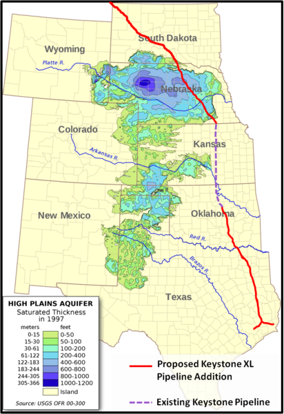
Depth and location of Ogallala Aquifer

 As may be seen from the map on your left, the ecologically sensitive areas under discussion that begin adjacent to the tar sands deposits in Alberta, Canada, continue into the High Prairie potholes of North Dakota, through the James River watershed, Cottonwood Lake and the COTEAU DU MISSOURI, andcrosses portions of the Ogallala Aquifer .

The underlying glacial pothole formations do not lend themselves to easy drainage, are susceptible to fluid transfers between layers, are permeable to exterior elements contamination, and exchange surface liquids with the underlying aquifer with ease. 

 The Ogallala aquifer has emerged as an important point in the debate. In June, two scientists from Nebraska called for a special study to determine how an oil spill would affect it, and Republican Sen. Mike Johanns of Nebraska has asked the State Department to consider an alternate, more easterly route that would avoid it. Twenty scientists from top research institutions recently signed a letter urging President Obama not to approve the pipeline because of environmental concerns.

 Because it's the most heavily used aquifer in the United States and supplies about 30 percent of the groundwater pumped for irrigation nationwide. The Ogallala aquifer (also known as the High Plains aquifer) covers 175,000 square miles, an area larger than the state of California, and spans eight states — Nebraska, South Dakota, Wyoming, Colorado, Kansas, Oklahoma, Texas and New Mexico. 

  A valve broke at a pumping station in southern North Dakota along the first leg of its Keystone pipeline system. The breach released about 500 barrels of Canadian heavy crude inside the facility and set off a geyser of oil that reached above the treetops in a nearby field. It was only ten months ago that the pipeline began transporting bitumen from Alberta's oil sands mines to refineries in Patoka, Illinois. ( Stacy Feldman, InsideClimate News and Elizabeth McGowan)

Needless to say, there can be no mistakes here, not with the lives,drinking water and food supply of  millions Americans at risk. The ecosystems mentioned here are only the largest and most well  known. From the arboreal forests of Alberta Canada, glacial tills of the High Plateau, the wetlands of the Dakotas and the Missouri River Watershed, the treasures of Utah, Nebraska all the way through Texas, this is a gift  to be treasured and protected at all cost. 


The certain ecological damage to wildlife and the natural resources of our Great Plains breadbasket is too precious to risk for a few drops of oil that will enrich only a few and do nothing to add to our American jobs or energy independence. Even if that were not true, we still could not afford this debacle. The destruction in Alberta, in our American west, the multiple dangers of pursuing these out dated and destructive projects is the epitome of arrogance. For only a fraction of the fortune that is being reaped from our lands, and investment of true American spirit, renewable energy could be ours in our lifetimes.  As the space program was created and successfully implemented in the 1960's through sheer political will and popular support, so can we today continue creating the necessary energy technologies to eliminate the need for these destructive and fatal practices. It is the height of foolishness to even consider moving forward into the future with the old end game of dirty oil, toxic lands, polluted water and unbreathable air.  Worse yet, to see all that is precious to us be destroyed by the avarice of greed and the Worship of Mammon would be a failing of monumental and irreversible proportions.


Wednesday, October 26, 2016

Standing Rock Stands on Free Speech

BREAKING: Feds Shoot Down Furious North Dakota Cops and DAPL Corp, Telling Them There Are No Grounds To Evict Growing Pipeline Protest Camp


The growing encampment that is a living, breathing protest against the four-state Dakota Access pipeline has most everything it needs to be self-sustaining: food, firewood, fresh water and shelter. Everything except, according to Republican Rep Kevin Cramer, permission to be on the federal land in North Dakota.
According to James MacPherson of Time, Federal officials say they will not evict the Oceti Sakowin, or Seven Council Fires camp, due to free speech reasons, even though it’s on U.S. Army Corps of Engineers land near the confluence of the Missouri and Cannonball rivers that many Native Americans believe is still rightfully owned by the Standing Rock Sioux under a nearly 150-year-old treaty.
“We’re not leaving until we defeat this big black snake,” camp spokesman Cody Hall said of the pipeline.
Republican U.S. Rep. Kevin Cramer, North Dakota’s only House member, has sided with the pipeline company against the protectors and believes the camp is illegal.
“If that camp was full of people advocating for fossil fuels, they would have been removed by now,” Cramer said. “There is some discretionary enforcement going on.”
Primary encampment
 Oceti Sakowin Camp.Cannon Ball, ND
The camp is the overflow from smaller private and permitted protest sites nearby and REALLY began growing in August. The gathering has been called the largest gathering of Native American nations in history, all there to protect the land and water from Dallas-based Energy Transfer Partners’ $3.8 billion Dakota Access pipeline, which officials say threatens sacred sites, burial grounds, and a river that’s a source of water for millions. The company has already destroyed some sacred areas while using hired security forces with pepper spray and attack dogs to try to hold back the protectors.
MacPherson also notes that Corps spokeswoman Eileen Williamson said the agency is encouraging people to relocate to areas where there is a permit, such as a nearby smaller camp where demonstrators have been allowed to legally protest on federal lands managed by the agency.
Williamson mentions the pesky “free speech” that Americans are allowed:“We don’t have the physical ability to go out and evict people — it gives the appearance of not protecting free speech,” she said. “Our hands are really tied.”
Cramer speculates, without evidence, that the “bigger problem” of the camp is “the illegal activity that may be orchestrated from there.”  About 95 people have been arrested in the pipeline protests, some as far as 70 miles away from the camp, since early August, but none at the camp itself. Protectors deny state officials’ false charge, and Hall says the camp promotes peaceful protest.
“People don’t leave from the camp with malicious intent to do harm,” Hall said. “There are always going to be a few bad eggs in any group you can’t the message to.”
Complicating the issue is a grazing lease on that land. The renter, David Meyer, is responsible for the condition of the land. He could enforce his lease and have people removed, Williamson said, but hasn’t requested any intervention. Meyer recently sold part of his historic Cannonball Ranch to Energy Transfer Partners for an undisclosed price; he hasn’t returned telephone calls from The Associated Press seeking comment.
 
The Standing Rock Sioux has challenged the Army Corps of Engineers’ decision to grant permits for the pipeline that is intended to carry North Dakota oil to Illinois. Due to a federal court decision, construction has stopped within 20 miles on either side of Lake Oahe, a Missouri River reservoir that is near the encampment. The Departments of Justice, Army and Interior also has said it will “reconsider any of its previous decisions” on land that borders or is under the lake.
Hall, a member of South Dakota’s Cheyenne River Sioux Tribe, said the Sioux “never ceded” the land on which they’re camping. He said they are preparing to stay through the winter by stockpiling firewood, heating stoves and warmer clothes. But there’ll be no permanent structures built, Hall said.
“We will leave this camp as we found it,” he said.
So who’s land is it? According to the treaty, it is the land of the Natives, but according to some, it is the land of the Army Corps of Engineers. Are the treaties still respected or are they forgotten in favor of money? Either way, the Corps said they will respect “free speech” for now and allow the camp to continue! 

Thursday, October 20, 2016

 The Family Group of William Brown.
~
by Justin Sanders.


The earliest known ancestors of our Brown line were William and Ann Brown of Bristol Parish, Henrico County, Virginia. Although records pertaining to this couple are few in number and span only a sixteen-year period, those that have been located suffice to offer a basic understanding of their family group.
The earliest record found thus far shows William and Ann were residing in Henrico County by 1721, the year in which their youngest known son, John, was born. A single-line entry in the birth registry of the Bristol Parish Vestry Book, states: “John, s/o William & Anne Brown, b. Aug. 30, 1721.” 1
Henrico County was the second settlement of the Virginia Colony, established in 1611 a short distance upriver from Jamestown. In 1721 the county and Bristol Parish encompassed a vast area that was later subdivided into several jurisdictions. Unless an earlier deed is found, it is impossible to say for certain where William’s family was then located. Within a few years of that date, however, a pair of land records hone William’s whereabouts into a small pocket in present-day Chesterfield County.
1 Births from Bristol Parish of Henrico, Prince George and Dinwiddie, in Bristol Parish Vestry Book, p. 5.


http://search.ancestry.com/Browse/BookView.aspx?dbid=49093&iid=FLHG_BritishBristolParishRegiHen-0125


The White Man Came to Stay: WPA Writers Program 1941 (Sponsored by Franklin Co Va. School Board)